
Thermal Imaging Leak Detection for Underground Water Pipes
Thermal imaging leak detection for underground water pipes, irrigation networks and pipelines, analysed and certified by a Level 3 thermographer.
A leak on a buried pipe is often known about long before it is found. Water use climbs, pressure falls or a patch of ground never quite dries, but the run is long and excavation is the slowest and most costly way to search. Thermal imaging can narrow that search to the places most consistent with escaping water.
Thermography Services (UK) analyses thermal survey data of underground and external water pipes, from mains and estate supplies to irrigation networks and pipelines, and reports every candidate leak location in a certified Level 3 report, ready for a leak detection contractor to confirm on the ground.

Fewer places to dig, and every one of them backed by certified thermal evidence.
Water escaping from a buried pipe changes the ground around it. Wet ground holds and releases heat differently from dry ground, and the water may be warmer or cooler than the soil it soaks into. Captured at the right time, usually before dawn once the surface has settled overnight, that difference can show as a pattern on a thermal image, above and along the line of the pipe. On a long run, it can turn a search of the whole route into a handful of places to investigate.
Thermal imaging does not see the pipe or the water. It shows surface temperature, and plenty of things other than leaks change it. Reading the difference is the skill, and it is the part of the job that most needs to be certified.
That is where certified analysis earns its place. Our Level 3 thermographer reviews every thermogram from the survey, measures each possible location against a baseline taken on a normal section of the same pipe, and accepts a location as a candidate only when both its temperature and its shape depart from the normal pipe profile. Access covers, chambers, vegetation, surface repairs, irrigation water, vehicles and other buried services are checked against the visual imagery and declared, so what remains is a short list rather than a long one. Each candidate is classified, given a confidence and located, so a leak detection contractor can confirm it on the ground before anyone excavates. The service covers water mains and estate supplies, irrigation networks on farms, vineyards and estates, and buried pipelines, in the UK and internationally. Every report is written and certified by our Level 3 thermographer.
Thermal imaging leak detection for underground water pipes, irrigation networks and pipelines, analysed and certified by a Level 3 thermographer.
Page Subjects
thermal imaging leak detection, underground water leak detection thermal imaging, thermal leak detection report, irrigation leak detection thermography, pipeline leak thermal survey


Page Tags
water leak detection, thermal imaging, underground pipes, irrigation leaks, pipeline survey, Level 3 thermographer
Request a Leak Detection Quotation
Every network is different, so every leak detection job is scoped to the pipe, the ground and the data. Tell us what is being lost and where, what the pipe runs under, whether a survey has already been flown and with what equipment, and we will come back with a clear proposal and a quotation for the analysis, the data collection protocol, or both, as the job needs. A pipe map or a route sketch helps us a great deal.

How thermal leak detection works
What a Thermal Survey Shows
Most underground leaks are not a mystery in principle. Something is being lost: a meter reading climbs, a pressure test fails, or one stretch of ground stays damp while the rest dries out.
The difficulty is location. A main may run for hundreds of metres under a road, a yard or a field, and every trial hole costs time, money and disruption. A thermal survey looks at the surface above the pipe instead, for the places where the ground behaves differently from the rest of the run.
The physics is simple to state and harder to read. Escaping water changes how the ground stores and releases heat. On a cool night a wetted zone may stay warmer than the dry ground beside it; in other conditions, and in porous ground where moisture moves as vapour, it can show as cooling instead. The surface matters as well. Paved roads and drives tend to give clear, readable patterns, while open land and vegetation can hide a signature altogether, which is why a survey plan starts with what the pipe runs under.
Timing does a great deal of the work. Surveys are normally captured before dawn, after the surface has had the night to settle and before the sun loads it again, in dry and still conditions. Recent rain can mask a leak completely, and wind can strip away the very contrast the survey depends on.
Even then, a thermal image indicates rather than confirms. Thermography is an indirect, comparative screening method: it never detects water directly, and a candidate is a location where the surface evidence is consistent with escaping water.
That is why every candidate in our reports is presented for ground-based confirmation, and why each report states plainly what was surveyed, under which conditions and with what limitations. A short list that a contractor can trust is worth far more than a long one that sends them digging in the wrong places.
Capture, analysis and the report
Who Captures and Who Certifies
Leak detection from the air is two separate jobs. One is flying the survey: planning the route, the timing and the altitude, and capturing radiometric thermal and visual images to a consistent method. The other is reading that data, separating leaks from everything else that warms or cools a surface, and standing behind the result with a signature.
Thermography Services (UK) does the second. We analyse thermal data captured by drone operators, survey companies and network owners, and issue a certified report. Where the survey has not yet been flown, our Level 3 thermographer can write a data collection protocol for the route first, so the data arrives fit for analysis and nothing has to be reconstructed afterwards. Data already captured without one can still be analysed, with any gaps declared in the report.
Some clients would rather have the capture arranged for them. Drone Media Imaging flies aerial thermal surveys of buried mains and pipelines and will provide a quotation for the flight; the certified Level 3 analysis and report can then follow here, so the capture and the certification each sit with the team best placed to do them.
Whichever route you take, every report is written and certified by our Level 3 thermographer, and states the conditions, coverage and limitations of the data behind it.

Case Study
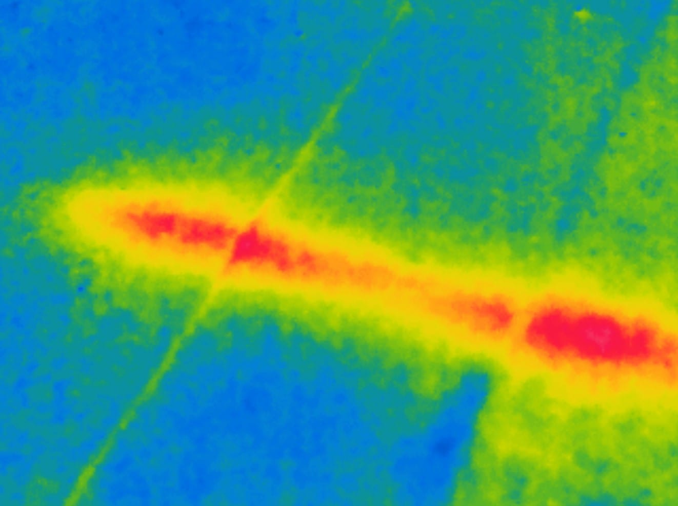
Winery Irrigation Leak Analysis in Lanzarote
Level 3 analysis and reporting of a pre-dawn aerial thermal survey at a winery estate in Lanzarote, with the aerial data captured by SKYNOX Drones SL, to investigate a suspected irrigation leak beneath a stamped concrete driveway. About 250 radiometric images were captured after the pipe network had been run for 24 hours beforehand. Triage narrowed the property to five locations. One primary high-confidence candidate held across three flight angles, and every competing explanation, from vegetation to building vents, was tested and declared.
Standards and Governance
Thermographic analysis and reporting are carried out by a Thermography Services (UK) ITC Level III Certified Master Thermographer (Infrared Training Centre; Certification #205722059), practising in accordance with the frameworks of ISO 18436-7:2014, ASNT SNT-TC-1A and ANSI/ASNT CP-105, and BINDT CMGEN Appendix B (UK training governance). No published international, European or national standard defines a method or acceptance criteria for airborne infrared thermographic detection of leaks from buried pressurised water mains. The analysis was therefore carried out to a documented procedure, aligned with the principles of ISO 10880:2017 and BS EN 16714-1:2016 for passive infrared thermography. All anomalies reported are candidate locations requiring ground-based confirmation.
Thermal Imaging Leak Detection
Underground water leak detection by thermal imaging
Thermal imaging leak detection is used where a loss is known or suspected on a buried or external pipe and the location is not. Underground water leak detection by thermal imaging suits long runs and large sites: municipal and private water mains, supplies across estates, campuses and industrial sites, irrigation networks on farms, vineyards and managed grounds, and buried pipelines between sites. Irrigation leak detection thermography often has an advantage, because the network can be run before the survey so that any escaping water has time to reach the ground around the pipe.
A pipeline leak thermal survey is normally flown by drone, at low altitude along the line of the pipe, in the hours before dawn. External water leak detection by thermal imaging can also be useful on shorter runs under drives, yards and car parks. In every case the data is only as good as the conditions and the method behind it, which is why we can write the data collection protocol before the survey and check the returned data before any analysis begins.
The thermal leak detection report
A thermal leak detection report from Thermography Services (UK) lists every candidate location with its classification, its confidence and its position, together with the ground verification recommended for each one. Behind the findings sit the working assumptions about the network, the limitations of the data, the method used and an annotated page for every reported thermogram, so each finding can be checked against its evidence. Leak detection thermography at Level 3 means the thermographer who classifies each location is the one who certifies the report, and the classification rules are written down before the analysis starts. Every report is written and certified by our Level 3 thermographer.
Water leak thermal imaging analysis narrows a search; it does not end one. Candidates are confirmed on the ground by a leak detection contractor, usually with acoustic, tracer gas or other methods, before excavation, and excavation, repair and ground investigation remain with the network owner or their contractor. The scope of the report is leak sites only. Other observations, such as route accuracy or disused runs, are outside it, and pipe routes are taken as supplied by the client, so an accurate pipe map is one of the most useful things you can send.
The service is national and international, and reports for clients abroad can be issued with a translation support companion beside the English report. Insurers and loss adjusters investigating an escape of water on an external supply can use the same report as evidence of where the investigation should focus. Leaks inside buildings, and water entering through roofs and walls, are covered by our building thermography service, including Flat Roof and Water Ingress Surveys.
Thermographic Testing Principles
The standard behind it
BS EN 16714-1:2016 sets out the general principles of thermographic testing, the family of non-destructive methods that read the surface temperature of an object to learn about what lies beneath it. Leak detection is passive thermography: it relies on natural heat flow, here the ground cooling overnight, rather than heat applied by the surveyor.
The standard covers the general principles of both passive and active thermographic testing, whatever the material being tested. It does not define a method or acceptance criteria for buried water pipes, and no other published international, European or national standard does either. Our leak analysis therefore follows a documented procedure aligned with the principles of BS EN 16714-1:2016 and ISO 10880:2017, and every report states that procedure and the limitations that come with it.
Request a Leak Detection Quotation
Every network is different, so every leak detection job is scoped to the pipe, the ground and the data. Tell us what is being lost and where, what the pipe runs under, whether a survey has already been flown and with what equipment, and we will come back with a clear proposal and a quotation for the analysis, the data collection protocol, or both, as the job needs. A pipe map or a route sketch helps us a great deal.


